FIND 2-Inch Nail In Baby’s Throat – Spokesman Review, 5 Nov 1921
Cut Child’s Windpipe and Use Magnet With Success
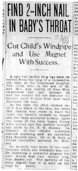
A nail two inches long as been removed from the lung of a 15-month-old baby at the Deaconess hospital. The child, who is the son of Mr. and Mrs. Leo Dahlin of Nine Miles, swallowed the nail October 29th, and the mother did not discover the trouble until X-rays four days later disclosed the nail.
At the time the child choked (sic) until it was black in the face, but when Mrs. Dahlin was ready to start for town the trouble seemed to depart and the baby appeared normal. Later the lungs of the baby began filling with mucus and the mother brought the child to Dr. T.E. Hoxsey. On October 24 the child’s condition seemed alarming and an operation was decided upon. Dr. O.M. Rott, a through specialist, assisted Dr. Hoxsey.
An incision was made in the neck through which the windpipe was cut. But inserting a powerful magnet the nail, which was two inches long, was drawn out. The parents of the baby report that it is well on the road to recovery.
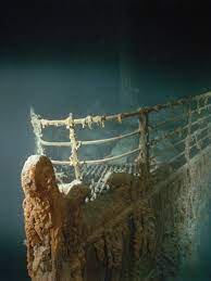
Who has not seen this fantastic image of the Titanic’s bow as she rests nearly a mile deep in the Atlantic:
Bet you did not know:
She was the largest moving man-made object until 1912.
Some 4000 workers took 2 years to build her in Belfast, Ireland
She cost $10,000,000 in 1912 dollars (about $322,000,000 today)
The 4-day, one way, first-class passage cost about $80,000 in 1998 dollars
Lifeboat requirements were based on tonnage, not passenger count
New York Evening Sun ran a headline: ALL SAVED FROM TITANIC
The 1997 movie, Titanic, cost 24 times what the ship itself cost to build in 1911 (you do the math!)
One body, still floating in its life vest, was found 2 months la
More than 3000 books have been written about the Titanic
The last funnel on Titanic was “dummy” for ventilation and aesthetics and no smoke came out of it
The Titanic Historical Society, founded in 1963, has 5000 members; PO Box 5153, Indian Orchard MA 01151
********************
August, 2023: Miami, Florida: Archaeologists have found a submerged gravestone in Dry Tortugas National Park near the Florida Keys and they say the discovery could also mean there’s a cemetery and hospital in the area. The site could have been used for quarantined yellow fever patients on a small island that has since eroded into the sea.
*********************
Jeanne Coe, a longtime member of EWGS, does indexing under the SCRIBE project for the Washington State archives. She notes odd and unusual names………. like these:
America Jane Chamberlain, b. Oregon
Ralph Oregon Dunbar, b. Illinois
Mary Nevada Kiner, b. 1877 in Iowa
Nevada Melvina Cameron, b. 1901 in Washington
Hazel Inez Price, b. 1892 in King County, WA; her father was Lake Erie Price, b. Minnesota and her mother was Capitola Albatross Fuller, b. Kansas.
Denver Colorado Sayler, b. 1906 in Kansas
********************
From Kenneth Roberts’ book, “Trending Into Maine,” published in 1938, I learned that the Salish word for white person was soo-yap-ee, which meant “upside down face.” This happened because most 19th century Euro-American men wore beards.
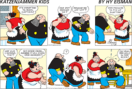
What would you guess was the longest running newspaper comic strip in the U.S.?? A strip most like your grandparents laughed over?
If you guess the Katzenjammer Kids, you win a prize! This strip ran from 1897 t0 2006. Next in order were…… do you read any of these today? Which ones might you remember your parents, or grandparents, chuckling over? P.S. They’re not all carried in our local newspaper. Makes one wonder how they can still be relevant today…… Prince Valiant?
Gasoline Alley – 1918 to now
Barney Google & Snuffy Smith – 1919 to now
Little Orphan Annie – 1924 to 2010
Popeye – 1929-1994
Blondie – 1930 to now
Dick Tracy – 1931 to now
Prince Valiant – 1937 to now
Brenda Starr, Reporter – 1940 to 2011
Beetle Bailey – 1950 to now
Dennis the Menace – 1951 to now
B.C. – 1958 to now
Since we’re enjoying humor today, here’s a “Chuckleberry” for you (from the Huckleberry Press): “Okay, so a Texan rancher comes upon a farmer from Maine. The Texan looks at the Mainer and asks, “Say, how much land you think you got here?” The Mainer answers, “Bout 10 acres, I’d say.” The Texan (boasting), “Well, on my lot, it takes me all day to drive completely around my property.” The Mainer (doubtless with a straight face) replies, “Yep, I got one of them trucks too.”
A grave blanket is a handmade or commercially made evergreen arrangement that covers the ground of the grave. They are made of evergreen boughs and can be decorated with ribbons, bows, flowers, pine cones or baby’s breath and are available in a variety of styles and sizes. Grave blankets are most often found in colder, northern regions of the country where traditional flower arrangements would not withstand the cold temperatures or snow. There are many reasons why grave blankets are placed on the graves of loved ones. The symbolic meaning is that the blanket will keep your deceased loved one warm for winter. Another reason is to honor and remember your beloved family member or friend.
** To Forget Is Vain Endeavor. Love’s Remembrance Lasts Forever.
In April 2023, I was blessed to take a deep dive into the history, geography, geology and culture of the far northeast corner of America, the Canadian Maritimes and the St. Lawrence River and Seaway. Con su permisio, as they say in Spanish, I would like to share with you some of what I learned in these blog posts over the next couple of months. Hope you benefit and enjoy!
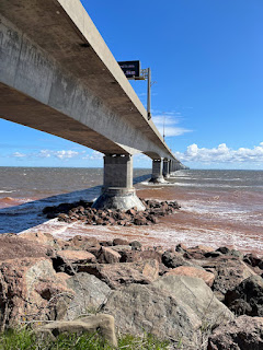
The Confederation Bridge was and is a very big deal for the Canadian Maritimes. Under the terms of Prince Edward Island’s entry into the Confederation in 1873, the Government of Canada was obligated to provide “continuous” and “efficient” year-round transportation for people, goods and services between P.E.I. and the mainland. Before the bridge, ferries were the only transportation to the island. Completed in 1977, the 12.9 km (just over 8 miles) bridge was built by 2500 men and women, most having no experience to work on a project of this size in such often often harsh, frigid weather. It took our bus about ten minutes to cross the curved 8-mile bridge; curved “to ensure that drivers remain attentive and reduce the potential for accidents that experts believed happen more often on straight bridges.”
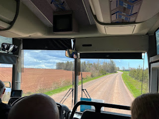
The red (iron-rich) soil of Prince Edward Island (named for the son of King George III) is known world-wide for potatoes. Over 80 different potato varieties of spuds are grown on over 800 acres. The residents of P.E.I. are nicknamed “Spudheads” for good reason.
F.Y.I. Spokane County is 1781 square miles; P.E.I. is 2185 square miles. “Our island has 200 churches, many big stone churches built in the 18th century. We either are very good or very bad,” quipped the tour guide.
YES, Anne of Green Gables is a premier tourist attraction on P.E.I. but I opted for the bridge.
In April 2023, I was blessed to take a deep dive into the history, geography, geology and culture of the far northeast corner of America, the Canadian Maritimes and the St. Lawrence River and Seaway. Con su permisio, as they say in Spanish, I would like to share with you some of what I learned in these blog posts over the next couple of months. Hope you benefit and enjoy!
“Everything about lobsters depends on temperature!” taught David, the history presenter on our ship. He then explained that in the day, lobsters were so plentiful off the coast of New England that prisoners complained that they not be fed lobster more than three times a week! William Bradford wrote: “The best dish they present to us was a lobster without bread or anything and only a glass of spring water.” But they soon became looked down upon and fed to prisoners. By the mid-1800s, lobster in New England was cheaper than chicken so the turn-around began.
Lobster must be cooked in boiling water, 212o F. The perfect temperature for a cooked lobster tail is 140o.
Lobsters must be kept alive for once dead they spoil rapidly. Temps between 32o and 40o is the water temp ideal for keeping lobsters alive during shipment. And they are shipped around the world. (And you wonder why lobster is so expensive?)
Optimal seawater temp for lobsters is 59o; waters of this temp are found in the Atlantic from Labrador to Cape Cod. Lobsters are cold blooded and lobster larvae grow proportional to temperature. If the temp is just right, they grow rapidly and when mature enough the floating larvae sink to the bottom to grow up. It takes 7-8 years to grow a mature lobster. They are cannibalistic so farming them does not work. (And you wonder by lobster is so expensive?)
If the water temp rises to 68o (or above) the lobster experiences “psychological stress” (taught David). The Gulf of Maine has warmed faster lately than 99% of the world’s waters (taught David). So as the southern water warms, the lobsters migrate north into colder water and the fisherman must move with them. David said that a 7.7o temperature rise in bottom ocean waters is expected by the year 3000…………what will Maine do?
Anyone who visits Maine likely craves Lobster Roll sandwiches the rest of their life; I know I do. Fairly expensive, a typical “roll” contains one pound of lobster meat. I can taste it even now!!
In April 2023, I was blessed to take a deep dive into the history, geography, geology and culture of the far northeast corner of America, the Canadian Maritimes and the St. Lawrence River and Seaway. Con su permisio, as they say in Spanish, I would like to share with you some of what I learned in these blog posts over the next couple of months. Hope you benefit and enjoy!
Some things have never changed throughout history; this is a sad-story truth. Two speeches, by two First Nations chiefs, separated by 3000 miles, reflect the same sentiment. (Seattle on the top.) In 1871, Chief Sweetgrass, a Cree, responded to Lt. Gov. Archibald regarding a treaty: “Great Father, I shake hands with you and big you welcome. We heard out lands were sold and we did not like it; we don’t want to sell our lands; it is our property and no one has the right to sell them. We want you to stop the Americans from coming to trade in our lands and bringing firewater.”
Everybody conveniently forgot a 1763 Royal Proclamation: “Lands which not having been ceded to or purchased by us, are still reserved for the Indians.”
In 1854, Chief Seattle, Duwamish tribe, spoke these words (the full speech printed out on four pages): “The great, and I presume, good, White Chief sends us word that he wishes to buy our land but is willing to allow us enough to live comfortably. This indeed appears just, even generous, for the Red Man no longer has rights that he need respect and the offer may be wise, also, as we are no longer in need of extensive country.”
Chief Seattle’s words continue: “Your God is not our God! Your God loves white people and hates mine! He folds his strong protecting arms lovingly about the paleface and leads him by the hand…. but he has forsaken his red children, if they are really his. Our God, the Great Spirit, seems also to have forsaken us. Your God makes your people wax stronger every day; soon they will fill the land. Our people are ebbing away like a rapidly receding tide that will never return. The white man’s God cannot love our people or he would protect them.”
How can we not be moved to better empathy and understanding by these words??
In April 2023, I was blessed to take a deep dive into the history, geography, geology and culture of the far northeast corner of America, the Canadian Maritimes and the St. Lawrence River and Seaway. Con su permisio, as they say in Spanish, I would like to share with you some of what I learned in these blog posts over the next couple of months. Hope you benefit and enjoy!
“The humble, hard-working beaver is honored on the Canadian nickel and for good reason. The beaver is an animal that was the architect of the nation of Canada,” explained David, our ship’s history presenter. “It was beaver fur that first drove exploration and exploitation.”
“The beaver is not leading-man material,” David quipped,” but is well adapted to its aquatic life. Its engineering acumen is what makes it outstanding. Its behavior comes from its genes; they are genetically programmed to build. Their ability to do it well develops over time and with practice. The longest known beaver dam is in Northern Canada and is over a mile long.”
Beavers are revered in Canada for a different reason. So what made it such a star? Its FUR! Fur trading was a big part of the economy since the first white explorers arrived. Samuel Champlain established a fur trading post in what became Quebec City in 1608. There were other fur-bearing animals but beaver were the most plentiful, were easy to find and catch. The First Nations were happy to trade beaver furs for the white man’s goods. Beaver fur was the currency of the frontier. As the beaver were trapped out, people (forts, towns) moved west with them. By the 1850s, the west was “beavered out” clear to the Rocky Mountains.
Today it’s hard to realize the great demand for beaver fur. Fashion drove the industry in the early 1800s: beaver hats were “the thing.” Luckily for the beaver, by the 1850s fashion was changing. Queen Victoria’s consort, Prince Albert, wore a silk top hat and quickly beaver hats were out. The beaver’s work was done; Canada was established.
By 1867, Canada was a nation built in many ways upon the humble beaver. To honor this “founding father,” the beaver is featured on the Canadian nickel.
In April 2023, I was blessed to take a deep dive into the history, geography, geology and culture of the far northeast corner of America, the Canadian Maritimes and the St. Lawrence River and Seaway. Con su permisio, as they say in Spanish, I would like to share with you some of what I learned in these blog posts over the next couple of months. Hope you benefit and enjoy!
By definition, an island in the St. Lawrence River & 1000 Islands area must meet these criteria: have at least one tree and at least one square foot above water year round. And actually, there are 1864 islands comprising the 1000 Islands area. These islands are mostly granite and the trees mostly deciduous ones. I spotted houses built on some TEENY rocky spots in the water….. accessible only by boat, obviously. No tides affect this area but due to the outflow from Lake Erie, the water can rise 3-4 feet from year to year. Called “Millionaires Row,” this area in the 1870s was the mecca for wealthy folks to build build their summer “cottages”……. mansions of 100+ rooms! President U.S. Grant visited a friend there one summer and the media blasted it well, bringing in new millionaires. In the day, these residents had 100+ foot long yachts with gleaming teak decks and built enormous boat houses for these boats.This area is more than a summering spot for the wealthy. The broad expanse of water in this area (and the many islands) resulted from the creation of the St. Lawrence Seaway. After years of yammering and problem solving between Canada and New York, construction of the seaway began in 1954 and was completed in 1959. Why was this important? The St. Lawrence River was THE artery into the heart of the North America continent and if it could be made navigable to the Great Lakes, the possibilities were endless.
The saddest story from human history standpoint was the submerging of nine villages, some Canadian and some American. Two towns/villages were relocated: Iroquois and Morrisburg. Nine were completely submerged: Aultsville, Farran’s Point, Dickenson’s Landing, Wales, Moulinette, Mille Roche, Woodlands, Santa Cruz and Maple Grove. Of course people shed tears, grumbled and filed lawsuits but in the end their towns and homes were relocated “for the greater benefit of the nations.” There is a Lost Villages Historical Society, founded in 1977, headquartered in Ault Park, near Long Sault, Ontario. Ten restored historic structures from Moulinette have been relocated there. If your ancestors lived in one of these Lost Villages, do contact this society: 16361 Fran LaFlamme Drive, Long Sault, Ontario, K0C 1P0. And perhaps watch the YouTube video, “No Road Home.”
This website has links to more history of each village.
Inundation Day, June 26, 1959, a ceremony was held in Montreal. Queen Elizabeth, President Eisenhauer and Prime Minister Diefenbaker were the speakers “affirming the grandeur of the project and all the good it meant to both Canada and the United States.”
In April 2023, I was blessed to take a deep dive into the history, geography, geology and culture of the far northeast corner of America, the Canadian Maritimes and the St. Lawrence River and Seaway. Con su permisio, as they say in Spanish, I would like to share with you some of what I learned in these blog posts over the next couple of months. Hope you benefit and enjoy!
Lighthouses. Who does not like lighthouses? How many of you have braved the 100-spiral-open-metal stairs to climb to the top of a lighthouse? (And remember than in days of yore, the lighthouse keepers would climb those stairs at least twice a day carrying fuel for the fire………. and there were women lighthouse keepers too, going up those stairs in their long dresses.)
Lighthouses are beautiful and romantic and have been featured in a million books and movies. “But what, really, is a lighthouse for?” asked David, our experience instructor on the ship. He continued, “A lighthouse is a navigation aid, surely not just by a light, but by a point to steer by. The lighthouse was the GPS of the 1800s. The lighthouse was a landmark visible at sea to enable recognition to ships of where they were. Anciently, shore fires wee used before lighthouses.” ****
“Imagine the coast of North America in the late 1800s. It was a broad expanse of rocky shores, forested wilderness, populated by the First Nations and then by lumbermen and fisherman,” David taught us. “In the mid-1800s there were hundreds of vessels from a dozen nations in North Atlantic waters for by water was the easiest mode of transport and transportation for both cargo and passengers. Today, modern ships navigate by GPS and other automated systems to keep safe on the water, but there were only lighthouses in the 1800s.”
“In the 1800s, sailing captains had only crude maps and a compass and sailors hoped for a captain skilled in these tools. Accidents occurred constantly….capsizing, beaching, grounding and collisions. The lighthouse was the technology of the day, built to make travel safer for the ships and people on the waters.”
*** On my Mississippi River trip in 2022, due to an extremely low river, we could not moor at Vicksburg but were diverted south to a hastily-extended concrete fishing access. Being up in the pre-dawn dark, I knew we passed Vicksburg and shortly in the pitch black darkness, I spotted a small, flickering light on the shore. As the ship’s floodlight zoomed in on that signal light, I could see that it was a beach fire! Lighted purposefully to guide us to where we could moor! So old time methods were still necessary in 2022!
You are free to copy articles to any non-commercial web site or message board or printed publication you wish. Don’t bother to ask permission, just do it.